Sheepwash Channel
Backwater in Oxford, EnglandSheepwash Channel connects the River Thames to the west and the Castle Mill Stream next to the Oxford Canal to the east, in west Oxford, England. To the north are Cripley Meadow and Fiddler's Island. To the south are Osney Island and the Botley Road.
Read article


Top Questions
AI generatedMore questions
Nearby Places

Oxford railway station
Railway station in Oxfordshire, England

St Barnabas Church, Oxford
Church in Oxford, United Kingdom
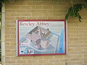
Rewley Abbey
Abbey in Oxford, England

Rewley Road
Road in Oxford, England

Isis Lock

Rewley Road Swing Bridge
Bridge in Oxford, England
Sheepwash Channel Railway Bridge
Bridge in Oxford, England

Tumbling Bay
Outdoors bathing area in Oxford